Canaã Copper Project Overview

Bravo has acquired a 100% interest in the Canaã Copper Project, covering approximately 6,185 hectares. The Project is located immediately NE of the city of Canaã dos Carajás, approximately 120 km southwest of Bravo’s flagship Luanga Project via paved roads. Canaã dos Carajás is a major mining centre in the Carajás region, with an estimated population of approximately 90,000 (Instituto Brasileiro de Geografia e Estatística, 2025), supporting Vale’s Sossego copper-gold and S11D iron ore operations, with well-developed infrastructure, mining services and an experienced workforce.

Canaã Copper is situated within the Canaã district of IOCG deposits and prospects, one of the most significant IOCG districts globally. The district extends approximately 50 km east-west, from the Alvo 118 deposit and Sossego mine in the west to the Cristalino deposit in the east. The Project hosts two historically drilled copper-gold prospects, Tapuia and Gueroba, as well as the Campo Grande target, where historical exploration identified copper-nickel mineralization associated with mafic-ultramafic rocks and lateritic Ni mineralization.

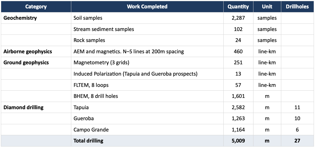
Between 2019 and 2024, OZ conducted extensive exploration across the project, including 2,287 soil samples, approximately 460 line-km of airborne geophysics, multiple ground geophysical surveys and 5,009m of diamond drilling in 27 holes. Drilling intersected IOCG-style copper-gold mineralization at Tapuia and Gueroba, although the relatively wide historical drill spacing leaves the geometry and continuity of mineralization insufficiently defined. Bravo has received the historical exploration database, drill core and sample pulps and is undertaking data validation, relogging of core and geological reinterpretation.

Proposed Work Program

Bravo’s exploration program at Canaã Copper will initially focus on better defining mineralization and potential extension at Tapuia, with approximately 5,300m of infill and exploratory diamond drilling planned on a 50 × 50 m grid across known mineralization and extensions. Landholder access agreements have been secured and environmental licensing for drilling is underway.

Additional work will also include geophysics (including borehole EM, if warranted), geotechnical logging, petrographic and mineralogical characterization and preliminary metallurgical testing to support a potential NI 43-101 mineral resource estimate. Additional infill and step-out drilling may follow, depending on results.

A second stage drilling program at Gueroba is planned following completion of drilling at Tapuia, with approximately 3,100 m currently planned.

The Canaã Copper project covers a large area, with its northern and central portions having received limited follow-up exploration to date. In parallel with work at Tapuia and Gueroba, Bravo plans to advance exploration across the broader Project, including the Campo Grande prospect, through geological mapping, additional soil and rock geochemical sampling, and follow-up geophysical surveys, including induced polarization (IP), with the objective of defining and testing new drill targets.
Location and Access

Access to the Project is very good, through a network of paved and unpaved roads. The Project area is almost entirely covered by medium to large cattle farms, in gently rolling topography in which the native vegetation has been replaced by pasture.

A government sponsored land settlement consisting of several small farms occurs in the SW corner of the project. Some native vegetation occurs along the southern edge of the project, associated with the Crimea mountain range.

The Municipal Park Veredas dos Carajás, a conservation area, occurs in this range but does not overlap with the Project area. A buffer zone to this conservation area has a small overlap with the property in its central-south limit area

Historical Exploration Work

Exploration was carried out on the Project from 2019 to 2024 by AVB Mineração Ltda. (“AVB”), then a subsidiary of OZ, under an option agreement with the project owner.

The exploration dataset, including drillhole core and pulps, has been handed over to Bravo. Historic work included extensive geochemical sampling (stream sediments and soils), airborne and ground geophysics. Table 1 summarizes the work completed to date.

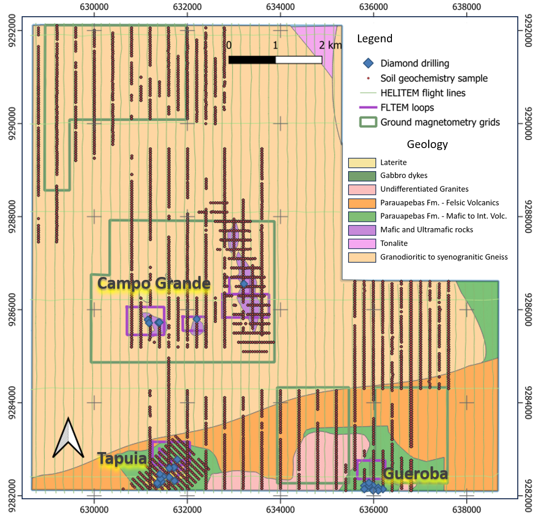
Bravo is currently undertaking validation the historic data including relogging of drill core, database validation, geophysical and structural reinterpretation. Figure 2 shows the main work completed at Canaã Copper.

Follow-up exploration on the main airborne electromagnetic and soil geochemistry anomalies resulted in the definition of three main target areas for IOCG mineralization: Tapuia, Gueroba and Campo Grande.

Subsequent drilling intersected Cu-Au mineralization in both the Tapuia and Gueroba prospects, whilst Campo Grande returned some narrow Cu-Ni mineralized intervals associated mostly with mafic and ultramafic rocks with hydrothermal alteration


Geology and Mineralization – the Canaã IOCG District

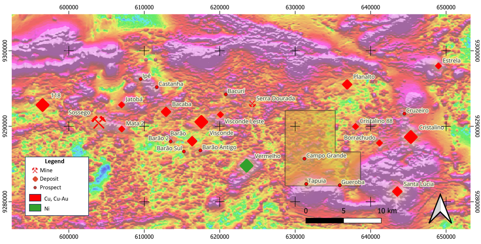
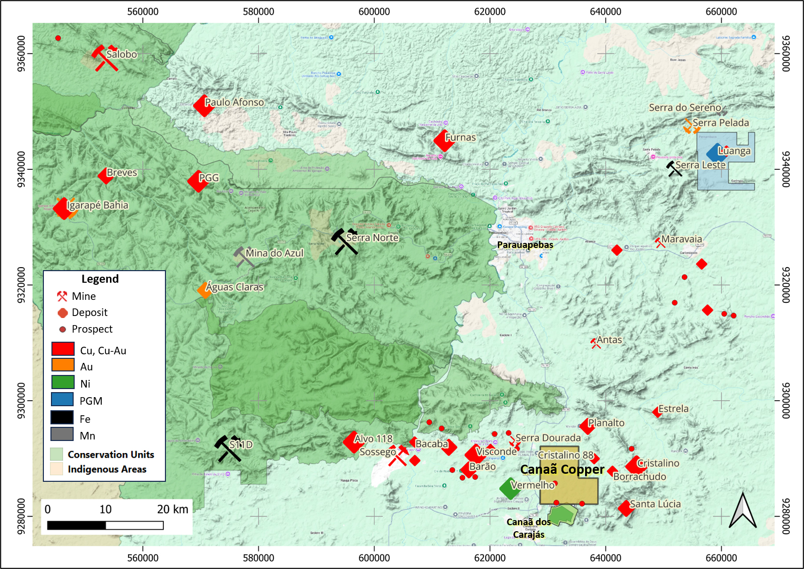
Main Deposits and prospects of the Canaã district over airborne magnetics (analytic signal)

The Canaã Copper Project is located in the southeastern portion of the CMP, within the Canaã district of IOCG Cu-Au deposits and prospects. The district, extending approximately 50 km east–west from Alvo 118 and the Sossego mine to the Cristalino deposit (Figure 3), is among the most significant IOCG districts globally, hosting numerous deposits and prospects, predominantly held by Vale Base Metals. CoreX operates the Pedra Branca underground Cu-Au mine in the region and is developing the nearby Santa Lucia Cu-Au deposit. The region also hosts Vale’s S11D iron ore deposit and the Vermelho lateritic nickel deposit.

The regional geology of the area is typical of the CMP and shows complex Mesoarchean to Paleoproterozoic evolution, containing Mesoarchean gneisses, migmatites and calc-alkaline granitoids of about 3.0 to 2.83 Ga; Neoarchean bimodal metavolcano-sedimentary sequences of the Itacaiúnas Supergroup, A-type granites (Planalto Suite granites), and mafic and ultramafic intrusions (2.76 Ga); and Paleoproterozoic A-type granites (1.88 Ga). IOCG deposits occur associated with large hydrothermal systems linked to regional shear zones and related structures or with the Paleoproterozoic A-Type granitic magmatism which drove hydrothermal systems that have directly formed or overprinted several IOCG deposits.

The Canaã Copper Project covers, in its northern and central areas, Mesoarchean and Neoarchean gneissic and granitic rocks. Several mafic to ultramafic lenses up to several hundred meters long lie within this domain and are well defined by the soil geochemistry and geophysics and can be correlated to the Neoarchean Vermelho complex. In the southern part of the Project, the Neoarchean Parauapebas Formation, comprising bimodal volcanic rocks and BIF lenses contact the gneissic and granitic rocks along an ENE trending structure (Figure 2).

Tapuia Prospect

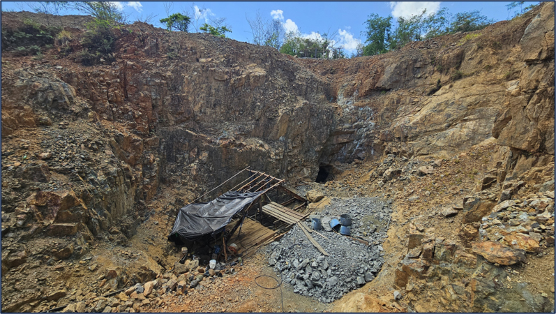
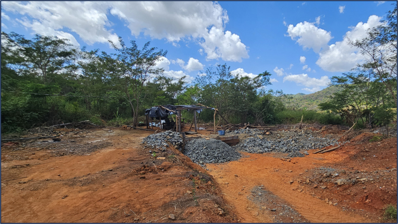
The Tapuia prospect is located in the SW of the Project and can be accessed via a 20-minute drive from Canaã. The target coincides with a small NE-elongated hill. The area has been subject to sporadic artisanal mining activity for Cu-Au sulphide material. One small open pit and three vertical shafts are observed (Photos a and b). 

Tapuia is marked by a well-defined, NE-trending copper-in-soil anomaly approximately 600 m long. A first-priority EM anomaly occurs some 300m to the NE, offset from the soil anomaly.

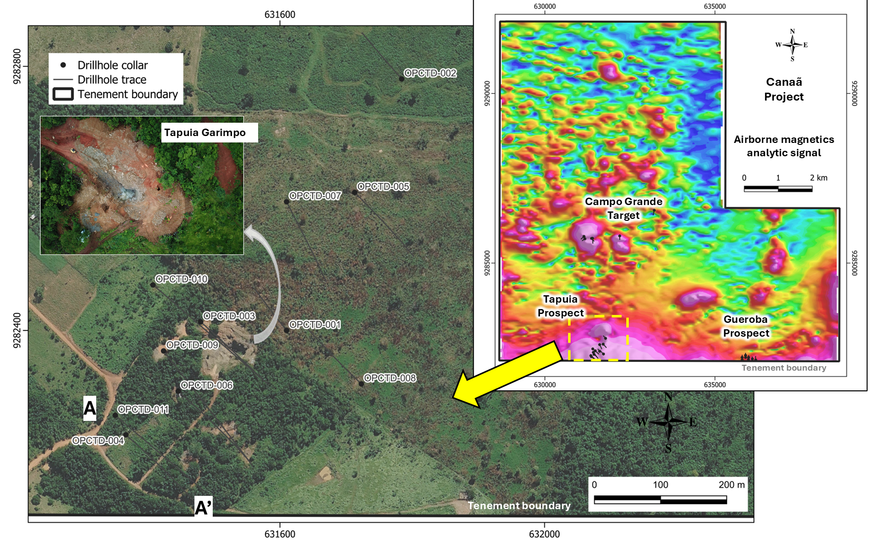
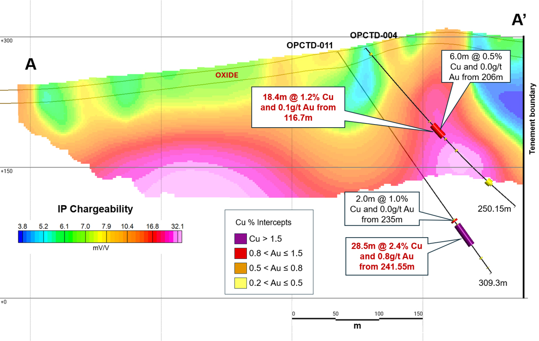
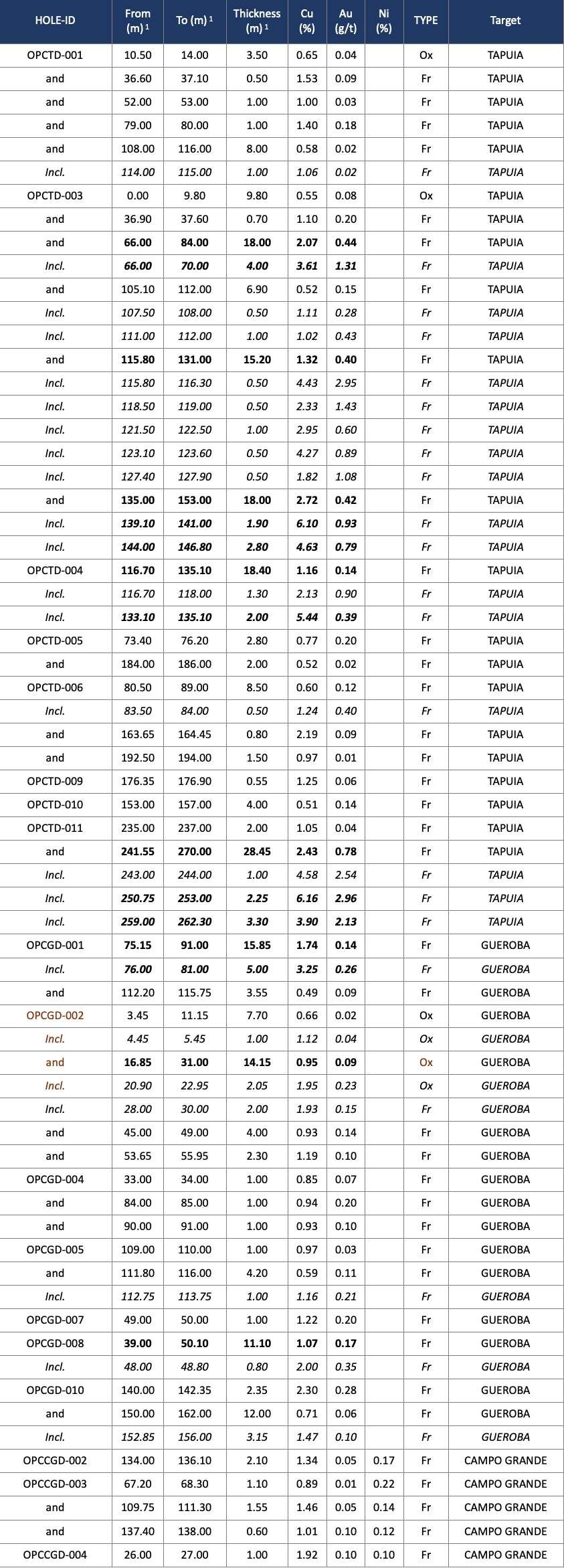
OZ drilled 11 holes for 2,582 m at Tapuia between 2019 and 2024, on NW–SE sections spaced approximately 100 m apart (Figure 4). Mineralization is interpreted as IOCG-type, consisting mostly of polymictic hydrothermal breccias hosted by mylonites, controlled by a NE-trending shear zone dipping steeply to the SE. Structural data suggest the mineralized shoots plunge at moderate angles to the southwest. The mineralized zone has been intersected over a strike length of approximately 300m. Schedule 2 presents all mineralized composites for the Canaã Copper Project, of which the highlights for Tapuia are:

  • OPCTD-003: 18.0m @ 2.07% Cu and 0.44 g/t Au from 66.0m1,
  • OPCTD-003: 15.2m @ 1.32% Cu and 0.40 g/t Au from 115.80m1
  • OPCTD-003: 18.0m @ 2.72% Cu and 0.42 g/t Au from 135m1.
  • OPCTD-004: 18.4m @ 1.16% Cu and 0.14 g/t Au from 116.70m1.
  • OPCTD-011: 28.45m @ 2.43% Cu and 0.78 g/t Au from 241.55m1.

Tapuia prospect drilling location.

Tapuia prospect drilling section over IP (chargeability).

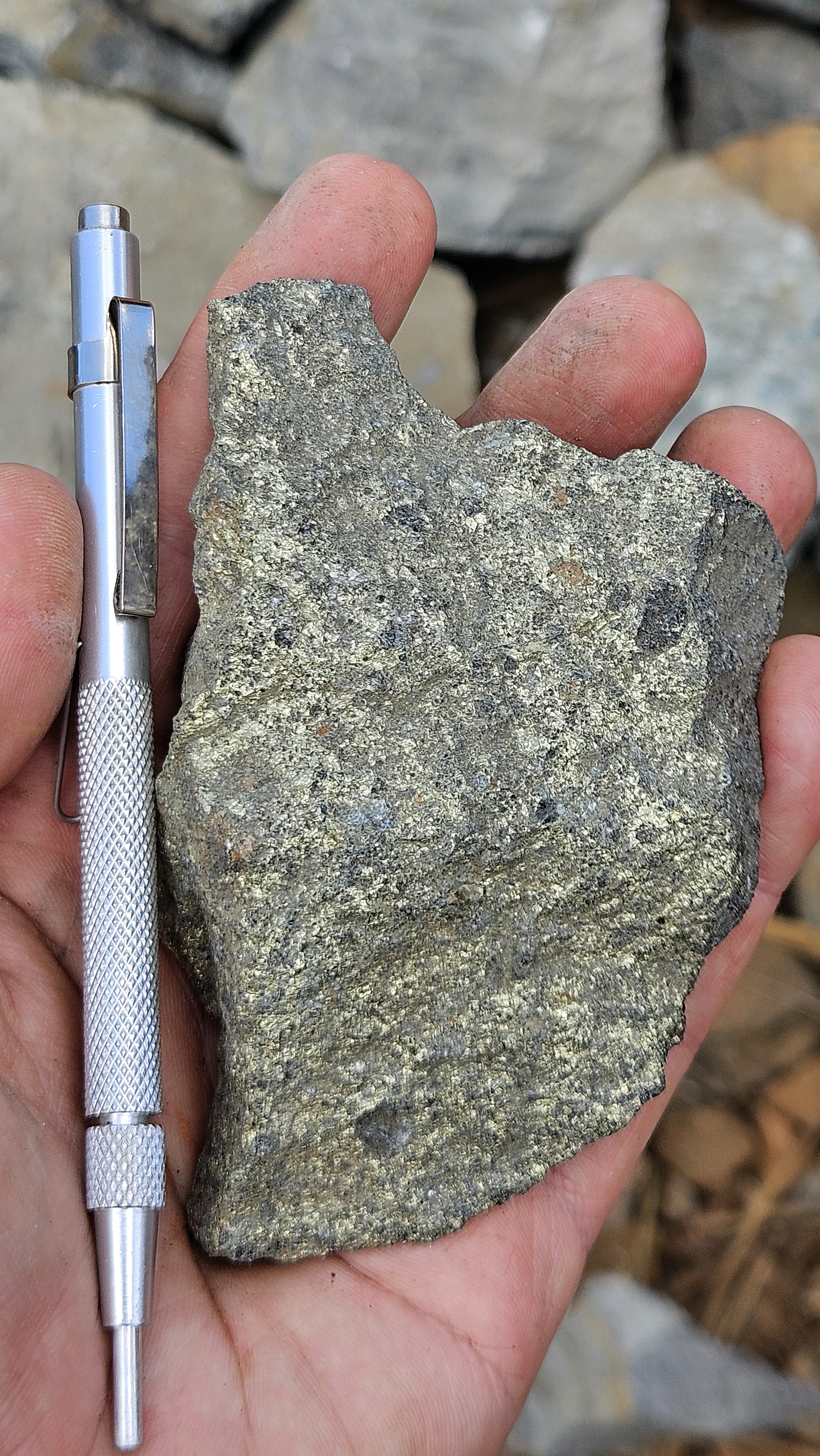
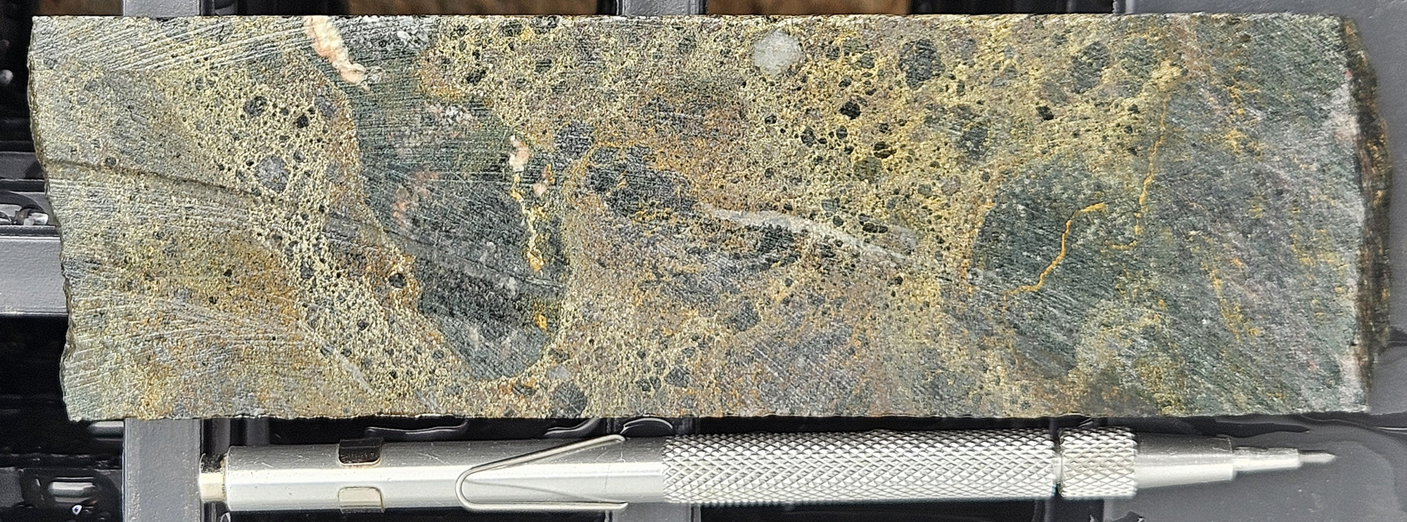
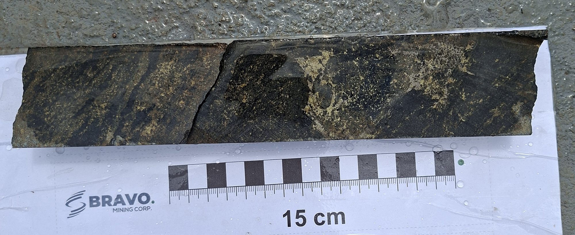
Based on Bravo’s relogging of drill holes OPCTD-003 and OPCTD-011, the host rock to mineralization is a strongly banded mylonite, with mafic and felsic bands, whose protolith is difficult to determine. The mylonite shows locally pinkish bands which are indicative of sodic alteration that was broadly coeval with, and subsequently affected by, deformation. At the edge of the mineralized zone, biotite (potassic) and scapolite alteration are observed. The main mineralization is hosted mostly in polymictic breccias. Fragments are mm to a few cm in diameter and composed predominantly of aggregates of amphibole and biotite, but also quartzo-feldspathic rock and quartz, set in a sulphide matrix where pyrite is greater in volume than chalcopyrite (Photo d). Some fragments contain earlier sulphide mineralization. The amount of sulphide varies and locally reaches 60%. Breccia material similar to that in drill hole OPCTD-011 was observed beside one of the artisanal mine shafts (Photo c)

There is currently no mineral resource estimate for Tapuia prepared in accordance with NI 43-101. Bravo believes that the drill spacing at Tapuia of 100 x 100 m between sections and a similar distance between drillhole pierce points on section is too wide for the size of the prospect and style of mineralization (Figure 5). In the material reviewed, OZ interpreted the mineralized zones as parallel tabular bodies dipping steeply to the SE. The planned drilling will test continuity and control of mineralization, which may occur as lenses within the shear zone in analogy to other deposits in the region.

Gueroba Prospect

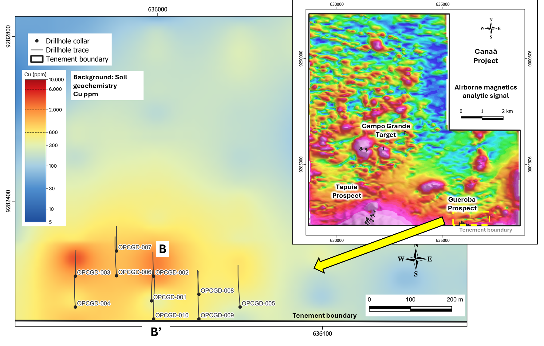
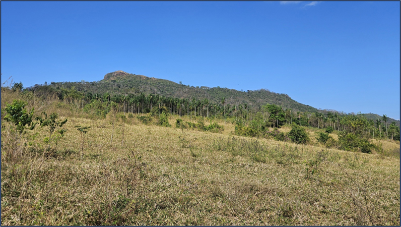
The Gueroba prospect is located in the SE of Project, approximately one hour’s drive from Canaã dos Carajás (Photo e). The target was defined by a 600 m long copper-in-soil anomaly coincident with a first-priority EM anomaly.

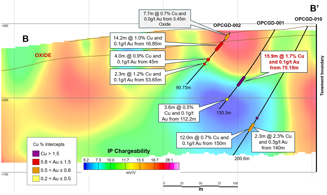
OZ drilled 10 holes for 1,263m at Gueroba on five N–S sections spaced 100m apart (Figure 6). Mineralization is interpreted as IOCG-style, interpreted by OZ as five subparallel narrow lenses that dip about 70° south with a shallow westward plunge along an E–W shear zone (Figure 7). Mineralization hosted in hydrothermally altered mafic volcanic rocks of the Parauapebas Formation and occurs as breccias, vein, veinlet and stringer zones, and semi-massive zones (15–60% sulphide) (Photo f). Intercepts are generally lower grade and narrower than at Tapuia. There is currently no mineral resource estimate for Gueroba prepared in accordance with NI 43-101. As at Tapuia, Bravo believes that the current drilling is too widely spaced to define the geometry of mineralization. The planned drilling on a 50 m grid will test the continuity of, and control on, mineralization. Highlights from prior drilling include the following:

  • OPCGD-001: 15.85m @ 1.74% Cu and 0.14 g/t Au from 75.15m, including 5.0m @ 3.25% Cu and 0.26 g/t Au from 76.0m1.
  • OPCGD-002: 14.15m @ 0.95% Cu and 0.09 g/t Au from 16.85 m1 (oxide mineralization).
  • OPCGD-008: 11.1m @ 1.07 % Cu and 0.17 g/t Au from 42.1 m1.

Figure 6: Gueroba prospect drilling location

Figure 7: Gueroba prospect drilling section over IP (chargeability).

Campo Grande Target

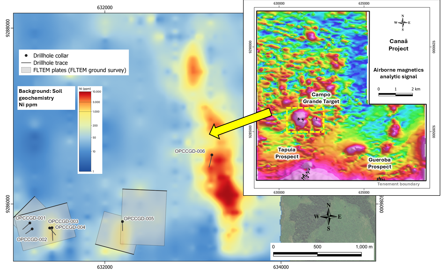
The Campo Grande target, in the central part of the permit, was defined by magnetic highs coincident with four high-priority AEM conductors and Cu and Ni anomalies in soils. As a follow up, infill geochemistry, four fixed-loop FLTEM grids and six drillholes were executed by OZ (Figure 8). The area is characterized by the occurrence of mafic–ultramafic rocks and lateritic cover.

Figure 8: Campo Grande target geology and work performed by OZ.

The six diamond holes (1,164.15 m in total) at Campo Grande tested mostly the FLTEM/AEM conductors. Host rocks intercepted are granodiorite to syenogranite gneisses, with serpentinised ultramafic bodies. Cu-Ni mineralization is associated to hydrothermally altered intervals. Highlights of this drilling include:

  • OPCCGD-002: 2.1m @ 1.34% Cu, 0.05 g/t Au and 0.17 % Ni from 134.0m1.
  • OPCCGD-003: 1.55m @ 1.46% Cu, 0.05 g/t Au and 0.14% Ni and from 109.75m1.
  • OPCCGD-004: 1.0m @ 1.92% Cu, and 0.10 g/t Au and 0.1 % Ni from 26.0m1.

Of note, a NNW-trending serpentinite body approximately 2.5 km long and 300m wide occurs in the eastern part of the target and is defined by anomalous Ni geochemistry, including an area 700m x 150m where Ni in soils is above 1% (10.000 ppm, the upper detection limit), indicating potential for lateritic Ni mineralization. A garnierite occurrence is observed in a small pit at the northern edge of this anomaly and two rock samples in this area returned above 1% Ni.

The results indicate that Campo Grande is prospective for iron oxide-copper-nickel (“IOCN”) mineralization, a deposit type related to IOCG but enriched in nickel, of which the Jaguar deposit is the main representative in the Carajás region. The area is also prospective for lateritic Ni and magmatic Ni-Cu-PGM mineralization.

Photos

a) Tapuia artisanal mine open pit with vertical shaft in the center.

b)Tapuia vertical shaft with ore pile.

c) polymictic hydrothermal breccia from vertical shaft ore pile, containing mm-wide fragments mostly of amphibole in sulphide matrix (approximately 60% in volume), where chalcopyrite > pyrite.

d) Tapuia OPCTD-011, 252.20m: polymictic hydrothermal breccia containing mm to cm wide fragments, rounded to angular, composed of amphibole aggregates (+biotite), quartz, quartz-feldspar aggregates in a matrix of fine grained sulphides (approximately 60% in volume) where pyrite > chalcopyrite.

e) Gueroba prospect in the background, behind the palm trees.

f) Gueroba OPCTD-001, 77.70m: hydrothermally altered mafic volcanic rock with 5% disseminated chalcopyrite and pyrite.

Technical Disclosure

Technical information in this news release has been reviewed and approved by Simon Mottram, F.AusIMM (Fellow Australian Institute of Mining and Metallurgy), President of Bravo Mining Corp. who serves as the Company’s “qualified person” as defined in National Instrument 43-101 Standards of Disclosure for Mineral Projects (“NI 43-101”). Mr. Mottram has verified the data disclosed in this news release to the extent described under “Historical Exploration Data and Data Verification” below.

The Canaã Copper property

The Canaã Copper property comprises exploration licence 850.510/2009, covering an area of 8,147.77 ha, located immediately to the NE of the city of Canaã dos Carajás. A Final Positive Exploration Report (Relatório Final de Pesquisa, “RFP”) was filed with the Brazilian National Mining Agency (Agência Nacional de Mineração, “ANM”) on July 1, 2021, together with a request for area reduction to 6,184.72 ha, as required under Brazilian mining legislation. ANM will now review the RFP and, if it meets the applicable requirements, approve it. Once ANM publishes its favorable decision, the titleholder acquires the right to apply for a mining concession (Concessão de Lavra). Bravo has lodged the documentation for the transfer of the exploration licence with ANM and is entitled to manage and undertake exploration on the property whilst pending ANM’s registration of the transfer.

Historical Exploration Data and Data Verification

The exploration results disclosed in this news release, including drilling, geochemical and geophysical results, are historical in nature. They were generated between 2019 and 2024 by AVB, then a subsidiary of OZ , before Bravo’s involvement with the Project, and are taken from OZ’s internal reports, files and database and from the Final Exploration Report filed with ANM in 2021. While Bravo believes the information to be data to be relevant and reliable, Bravo has not yet completed its independent verification of these data and is not responsible for the work completed by OZ.

Drill intercepts are reported as core lengths. True widths are not currently known; based on the interpreted geometry of the mineralization, true widths at Tapuia are expected to be less than the reported core lengths.

Mineral Resources

No mineral resources or mineral reserves, as defined by the CIM Definition Standards and NI 43-101, have been estimated for the Canaã Copper Project. The Final Exploration Report filed with ANM contains estimates prepared for the Gueroba prospect under Brazilian mining regulations. These estimates are not compliant with NI 43-101; a qualified person has not done sufficient work to classify them as current mineral resources or mineral reserves, Bravo is not treating them as current mineral resources or mineral reserves, and they are not disclosed in this news release.

Adjacent and Nearby Properties

This news release refers to mines, deposits and projects on properties near the Canaã Copper Project, including Sossego, Alvo 118, Cristalino, Estrela, Pedra Branca, Santa Lucia, S11D, Vermelho and Jaguar, which are owned by third parties. The QP has not verified the information regarding these properties, and the presence of mineralization on adjacent or nearby properties is not necessarily indicative of mineralization on the Canaã Copper Project.

References to Other Companies

References to OZ, BHP and CoreX are provided for historical context only. None of these companies has reviewed or endorsed this news release or Bravo’s interpretation of the historical data.

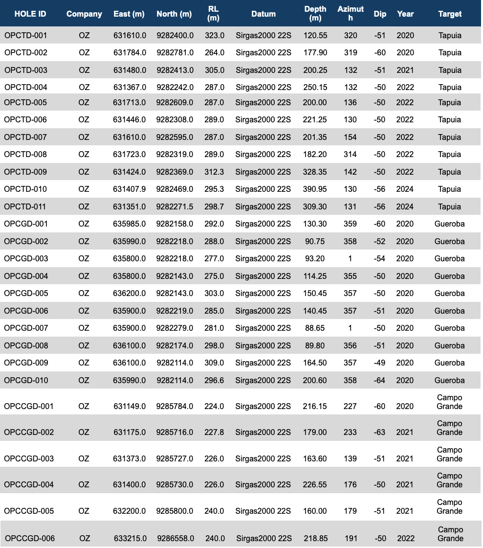
Schedule 1 – Drillhole Location Details

Schedule 2 – Drillhole intercepts at the Canaã Copper Project

Historical results from OZ Minerals. Intervals are core lengths; true widths are not defined. Composites calculated by Bravo. Samples with Cu assay results ≥ 0.5%, over intervals of > 1 m in length considered. Intervals include a maximum of 4 metres of internal dilution (grades below 0.5% Cu). Intervals equal to or less than 1 m in length are reported only where Cu results are ≥ 1%.

All ‘From’, ‘To’ depths, and ‘Thicknesses’ are downhole. All results in this report are historic, and given the historic origin, true widths and thicknesses are unknown.